Cross-View USA
Image Geolocalization, Autonomous Navigation, Image Synthesis
A large-scale benchmark supporting multiple tasks including image geolocalization, autonomous navigation, and image synthesis, featuring 1.58 million matched ground-to-aerial image pairs.
Matched Pairs
1.58 Million
Locations
879,318
Modalities
3
Citations
640+

Reference Publications
Papers that introduced this dataset
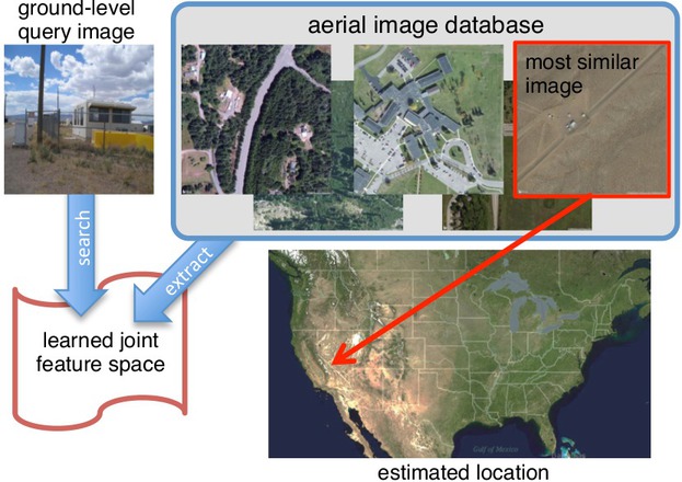
Wide-Area Image Geolocalization with Aerial Reference Imagery
Scott Workman, Richard Souvenir, and Nathan Jacobs
Dataset Details
Technical specifications
The Cross-View USA (CVUSA) dataset is a large-scale benchmark for Cross-View Image Geolocalization, Cross-View Image Synthesis, and Autonomous Navigation for UAVs. It provides 1.58 million matched image pairs across the contiguous United States to support research in learning joint semantic representations between ground-level and overhead perspectives. This data enables work in cross-view feature alignment, localization in GPS-denied environments, and generative image synthesis.
Dataset Features
Matched Pairs
- Scale: 1.58 million matched ground-to-aerial pairs across the US.
- Locations: 879,318 unique georeferenced locations, including roadway-centered and in-the-wild viewpoints.
Modal Diversity
- Street View: 1.03 million perspective views extracted from panoramas.
- Flickr: 551,851 geo-tagged "in-the-wild" social media images.
Multi-Scale Aerial
- Resolutions: High-fidelity 800x800 tiles at Bing Maps zoom levels 14, 16, and 18.
- Alignment: Centered at ground query locations for consistent cross-view matching.
Spatial Integrity
- Sampling: 100x100 grid binned collection strategy to eliminate urban bias.
- Filtering: CNN-based scene classification to filter for outdoor integrity.